AdSense

Showing posts with label Canadian Rockies. Show all posts

Jul 24, 2014

[Canada] Mt. Edith Cavell of Jasper National Park, a huge glacier can be seen cross section

The downside of excessive travel preparation stood directly in front of the stunning scenery film, already saw a lot of photos, so will not be surprised by. So, in addition to spontaneous travel path of the wind, no preparation is still doing visited this place remains intense in the mind map I do not know.

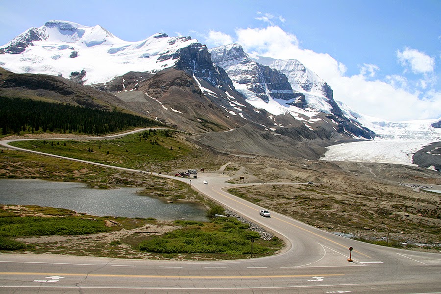
Canada Jasper National Park to the north of the Icefields Parkway to run 93A fall into the old, re-sign with Byway running a small to report. Dangerous because the narrow road with no center line of tourist buses and large camper over the entry way itself is a huge rock mountain appeared impossible. (National Park, see the map of the previous Travels)

The car was parked in the parking lot only to pull across a small creek trail began. Covered in snow-capped mountains visible behind a huge rock of 3,363 m above sea level, Mt. Edith Cavell. (Google Map Click here for a map)

"Mom, we walked up to where the calling?" The mother, of course, you do have to go to where the father, had no idea whether any future landscape unfold. doing none of preparation came from ... ^ ^

Shallow hill appeared before our eyes 'angel wings' Angel Glacier's appearance.

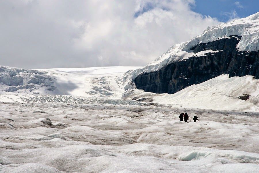
Made up the glacier trail ended here. Where we are now standing about 1,800 m above sea level looks back to Mt. Edith Cavell is here as well 1500 meters or more, especially in the thick of a glacial lake in the snow-covered mountain slopes as far as the height of a vertical cliff and said to be almost 1km!

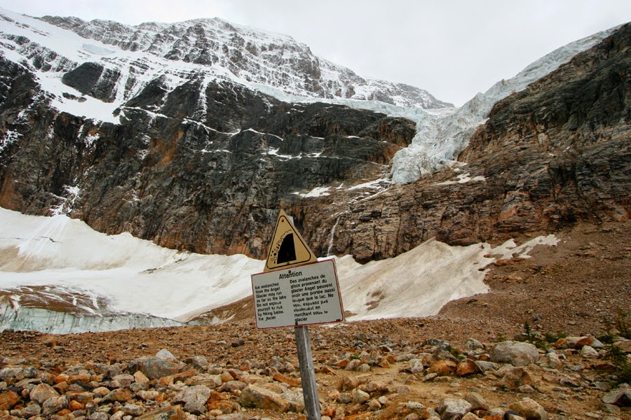
At any time over the cliff is a huge roll of ice and rock fall, so be very careful that there was a sign asking, you want to go closer to the heart could not suppress.

Looking at the location of a piece of ice from the glacier is clearly off from Angel must have been. Because of the sharp rocks and ice, it is dangerous to walk on the but as we move forward in what was spellbound. I have a small scar Eddie guidebook (Mt. Edith Cavell) is not even did the introduction, found later turned TripAdvisor (www.tripadvisor.com) out of a possible 100% of the Jasper National Park, where it was ranked among the top attractions.

Angel Glacier, where it looked really wide side like the wings of an angel. The highest waterfall of melted glacier water, which creates falling, people look at the bottom right picture, that is roughly the size of a cliff hanging glaciers will be able to guess.

I can not raise this is, Because of its landscape is the landscape looks of it ... ^ ^ back to almost black vertical cliff 1km height because it is seen on the lake surface Cavell Glacier is a cross-section of well over 100 meters in height that but the story, this picture does not realize this. But ...

Walks closer to the bottom right of the blue-dressed wife - 'overwhelming landscape "when writing the word is gonna do this!

Angel looking up in this place is one of white doves look like ice. The walk up the glacier, where the cross section of the glacier ice cave made Over water down (Ice Cave) also comes, ice sculpture as you can see, I did have to stop to go to was too dangerous. (Ice caves and waterfalls, glaciers, click here to view)

The crisis in this remote place to look to find a housewife who met with South Korea. California, Irvine, visit your relatives in Canada (friends?) You live with people who come to Vancouver, so we gave the family to take pictures. "Everyone is he doing well?"

Going to the lake, the ice is cracked or hear, that you could lose sight of the falls. The lake is quite high up across the meadows to climb out of a separate long trails, which end of the afternoon the weather was overcast and the rain started sprinkling was in a hurry to return to the parking lot.

Only now on his way to the bottom of the Angel Glacier saw pull zoom. (Even with the zoom function on the camera forget there was ^ ^) genus that this picture is nothing comparable to the size of the glacier, it is not only need something.

1-200 years ago, only now we were standing on the bottom is covered with ice, so now this is so barren stony grow new trees were hard. There is wisdom here is seeing signs up to be a dense forest, or covered with ice again only knew that the time had written.

The name of this mountain was active in World War I British nurse Edith Cavell, depending on the name came, the Germans occupied Belgium, even if she has not left all without distinction of friend and enemy wounded to care I saw more than 200 wounded Allied will be sent to the Netherlands because of the neighborhood they are considered to be a spy to have been executed by the Germans.

Mt. Edith Cavell to come back down the mountain to the north of Route 93A rests, Jasper National Park to spend the night camping is the way to find. Rocky mountain towering like a pyramid, angel wings, a resemblance glaciers, waterfalls, and the cross section of a huge glacier floating on the lake, and such a sad story of a British nurse before impression, there really unforgettable vivid rainbow summed up memories of the trip was not.

Jul 23, 2014

[Canada] I worry about global warming on Athabasca Glaciers in Columbia Icefield of Jasper National Park

Harboring the breathtaking Canadian Rocky ran 14 days of travel the Icefields Parkway in Canada drive! Time aimlessly past year, these photos again here in California, it is a dream for all of it ... I want to ...

Icefields Parkway just in the middle of the head of the Big Bend This exceeds the glacier appears again.

"This is done by looking at the landscape can quickly and 1500s have been! Which must build the car where ..." This idea is that by the time ...

Appears and the three-way junction and a large parking lot, made it to Canada flashing Jasper Ice Field National Park Tourist Information Center (Icefield Centre) is shown on the right. (Google Click here for location map) Wonderful turquoise railing going up the stairs of the building was impressive, and hung the Canadian flag 10003 I do not know why ...
The area opposite the building, the Columbia Icefields most famous Athabasca glacier seems, reading the description of the signs in 1844 that the glacier has completely covered up to now had been the parking lot! However, during the past 150 years, 1.5km or melted away, leaving the edge, I could end up halfway down the hill away.

Inside the building is the largest national park in Canada Jasper National Park begins with a sign indicating that the ancient glaciers (glacier) and the many exhibits are equipped with all amenities such as restaurants were.

But the most important feature of the tourist information center on the left side of the picture 'Glacier Experience' to be selling a huge table with wheels ride snowmobile ice climbing experience in the middle that allows you to be. However, the price is a whopping $ 49 per adult, $ 24, and the children! To save time, we have (?) ... One just decided to pass

Went up the glacier in the intersection, the left curved road riding snowmobile parking rises far out, and go right down to the top of the photo shown to the right will put the car in the parking lot at the end of the glacier can walk as far as looks. (Click on the top represents enlarged photo stick, ice climbing snowmobile across the middle and the bottom, you can see people apply)
Beyond the parking lot to the right of another glacier in Glacier Dome (Dome Glacier) is shown. Looking up ...

Looking at this angle, falling, glaciers is not icefall like they should be called ^ ^

Our family with strong legs (as expected of you ^ ^) in order to walk across the parking lot to see the glaciers came. Glacier trail signs for the entrance to introduce a number of UNESCO World Heritage Site, and has been described, with highland air is thin, so while the far right of the picture a bunch of people could fall as the kindly guidance set.

When you start to climb on top of me feel like I was going to be, is really quite bleak difficult uphill ... ~
It took about 25 minutes came up to the view point. While my wife and daughter smiling photo is quite difficult ... officially in a state where more foot climb up the glacier is prohibited for safety reasons. But behind the iron door, not a spectacular place to keep it stretched enough and the only one visible white line, as shown in the photo go over a lot of people standing on a glacier like stepping up to the present, I ... I could not hit the urge to root ~ ^ ^ So, the first wife, and wisdom, and went down to wait in the car, I ventured around is one!

Covered with the dust of the best ice in the bottom, then rises to walk in it was not very clean feel. shown in the photo, especially the cracked ice crevasses (crevasse) is there, the depth and the depth is 2 ~ 3m. In fact, previously frozen dead children lost in this accident because that will control for safety reasons. (Again, because it is officially off-limits, according to report in this article is, do not judge my style)

See the glacier in about 10 minutes to jump up low hill near the white ice cap is not supported.

So, this is about the illegal (?) To leave photos of the evidence is committed by 'habing' decided. (Well there you go - just took pictures ... ^ ^)

Two people in front of me to go take pictures of each other, gave evidence of a couple from Germany. The end of June glacier melt water in the hot sun so 'water album "creates the creek was flowing down, for some reason this seems to be good for the body and drank glacier water is sup-flowing ice streams are more down, more and more ice deep parser, small crevasses have been created, as shown above.

Athabasca glacier on the way back to the parking lot, taken down, which is displayed trail points in the middle of the year so there are many places that I could have come down from the glacier at this point tells us. It is also noticeable in the picture or on the rocks in the bottom vertical scratches, which is right at the bottom of the glacier come down out Over trace of a flat rock. That is, the softer rock solid ice 'planer' will ^ ^ The song was popular in the karaoke chorus of 'history is blurred-cow' is like a glacier flows. (How many know the song Lana?) True, global warming ... Global Warming ... Snowmobile the English, at a time like this. Glacier foot diameter feel the seriousness of the whole body. Our 25-minute walk up the darkness, she can not even take one hour later days.

[Canada] Lake Louise and the Icefields Parkway Jasper that connects Crowfoot Glacier and Peyto Lake

Peyto Lake between Lake Louise and the Icefields Parkway of Jasper National Park

Chapter meets in the morning ... for the first time in Canada before camping in Lake Louise (Lake Louise) and Moraine (Moraine) is really the spirit of the lake from hundreds of photographs taken under the laptop down. With a 30-day camping trip was invaluable Canon 400D camera and the Compaq laptop also comes up I'm gonna do this once ^ ^

Camping in the tall trees yesterday, did not know it overwhelming, so through the trees near the snow-capped peaks of the Rocky seemed covered with unforgettable Canada Banff National Park camping here to leave, traveling 14 days which today is Jasper (Jasper) National Park by bus.

Map of Lake Louise and Jasper like 93 times, connecting Canada about 230km section of road is 'Icefields Parkway (Icefields Parkway)' It's called a valley surrounded by snow-capped peaks of the blessed, custom-built tourist road, all over the world course of a reputation for a beautiful drive in the way. Points are on display in the middle of where we are willing Tofino pause only, in addition to many beautiful lakes and mountains are lined along the way.

Lake Louise to the west of Highway 1 from the cracked road after entering 93 times to announce the start of the tourist road signs are emerging are so many ways to prevent the National Park admission tests, in effect on the date of receipt to show tickets the. This is not my way to $ 100, but at about $ 20 a day by calculating the number of days to receive newsletter every National Park of Canada is the admission that it was indeed disagreeable. (Photo captured from Google Street View)

Icefields Parkway runs along most of the valley, because not so long Wiggly room to really enjoy the great outdoors and can drive. Tilt your head to pass, maybe once or twice, but did not quite summer, 230km bike is the way to see a lot of people are said to be running. There are several camping and hostel in the middle, but the gas station in Lake Louise from 3.1 to about 11 times the road and need to be careful only to meet Saskachewan. In addition, covered in snow from November to March is the winter passage of the chain can be sweet, but the operation of the road close to all facilities should keep in mind that it does not.

Our first stop was the point of this place is 34km from Lake Louise Lake of the Bow (Bow Lake) is. Sure where it is shown on the left should visit ...

The Crow Foot Glacier (Crowfoot Glacier)'s appearance. At the bottom of the first one hundred years ago, it had three toes up, and now it has melted away ditches. Moreover, among the recently broken toe that is getting to melt, this is the 'global warming' because ...? So, on this day the 'ice field (icefields)' while running throughout the day, worries about global warming far more than a lifetime to be in my life ^ ^

Early in the morning to watch the bow (Bow) lake is Lake Louise and Moraine Lake yesterday, and is also different. The red roof of the house across the lake that is?

Bow Summit and ran back to the car a little more arrived. This is literally the Icefields Parkway of 2085m above sea level, the highest hill in that head. Flowing into the hills south of Banff Bow (Bow) river begins, the four north Scarborough Saskatchewan (Saskachewan) river flows out along Route 11. Pulled up in the parking lot for about 10 minutes go up along the mountain path, the gentle, the most famous Icefields Parkway overlooking the lake can be seen ...

Just summer turquoise (turquoise) of the page Sat famous lake (Peyto Lake) it! (It's been a long time leads to panoramic photos attached - click to enlarge) is a glacial lake under the influence of minerals dissolved in striking such a bright turquoise, having gradually starting to snow fall color was changed to blue color is a clear, winter After catching the spring melt and then freeze again to change the color of turquoise is famous for getting a sharp knife. "Here, let's wait until the fall once ^ ^"

From early morning a lot of people from all over the world to see the lake full of observatory had gathered. So far the valley, downhill Icefields Parkway continues to lead to change, and in the river downstream of the lake to another lake to catch Miss (Mistaya Lake) for the figure seems.

11 Saskachewan Crossing the road splits east elevation is a lot comes down to near the rocky mountains of snow lowers are almost gone. A rock of a cliff on the mountainside that growing trees and grasses hanging, but also to wear, go to the bottom of the black and red burn marks I was wondering why it looks like.

Canadian Rockies again (Canadian Rocky) of magnificent mountains covered with perpetual snow goes running toward. Direct driving feel this way ... What can I say? Just fantastic!

Relatively gentle way to run long after, a big mountain to trek up the hill to the road made significant flex Big Bend (Big Bend) 'comes out the place, I stood on the hill looking back, so we were just down the length The past looks cool along the valley. Now, more than the entire car back up on the mountain, Jasper (Jasper) began the National Park, you can step on your own silver ice floe in Columbia (Columbia Icefield) will finally reveal the figure.