|
| Car ran over 9,000 km, 30-day U.S. / Western Canada's most unforgettable camping trip drive then plug in the course Introduction to the Canadian border down now Montana (Montana) in the state of Glacier (Glacier) National Park Going is-to-the-Sun Road. |
 |
| Glacier National Park in the east-west road that connects the village to the west of West Glacier to Lake McDonald to pass from beyond the Rocky Mountains, east of the St. 85km road ends at the town of Mary, which have been opened for the first time in 1932, the road itself is a National Historic Site (National Historic Landmark) and Civil Engineering (Civil Engineering) is referred to as a historic monument. (Glacier National Park Click here to see the map and check position by Google map click here) |
 |
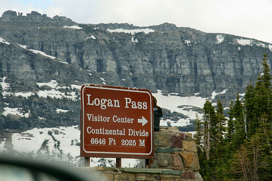
| Logan Pass of 2,025 m above sea level (Logan Pass) down the road past the west was indeed the way the cliffs made. 20m snowfall this winter because of the pass, the road from mid-June to mid-October, about four months, it's possible to pass. |
 |
| The end of June, even though the eyes of a sunny place and did not melt, so no fibers across the mountains pouring down like a waterfall creates. |
 |
| The highlight of the Weeping Wall in right here, tens of meters along the road that leads to the waterfall, we have to run him down. |
 |
| Necks facing car 'Red Jammer' Glacier National Park, called it a historic tour bus. Of course, that car is the latest natural gas-fueled vehicle, but it looks the same as 1930's tour bus will be designed specifically to one. |
 |
| Currently, the Going-to-the-Sun Road maintenance work is in progress, which is a long time, blocking the passage of so so so line is a lot of waiting time. But this landscape to see the car waiting for the videos, I felt a short time ... ^ ^ |
 |
| Haystack Creek falling from the sky (Haystack Creek) of the waterfall - |
 |
| Where to mow the cliff where the tunnel is created, what was the criteria? |
 |
| Slopes down to the road in danger when it was made, McDonald Creek in the woods along the road is quite modest lead. |
 |
| 961m above sea level at the bottom of the long bridge over Lake McDonald looks at the entrance to pull the rest. Go down a little bit more along the lake, where hostel and restaurant (McDonald's is not ^ ^) This resort is coming up in a moment, looking around in, we've been down that road and struck a tent placed over again St. Mary was starting up. |
 |
| From west to east the road, while the 180-degree turn, starting with a cliff hanging length "The Loop" to pass, so the passenger out of the car unfolds breathtaking unimaginable! Professional reflection in the rear view mirror that pose ^ ^ |
 |
| Google Earth is a three-dimensional look at the highlights section, The Loop, about 12km from the Logan Pass Area how steep mountain slopes can feel what made. (Click here to apply directly to Google Earth can see) |
 |
| Against the backdrop of the rugged rocky mountain pose these tough ^ ^ |
 |
| This rapids flowing water to create a place down the road, making the road set up so that the water is not flowing. |
 |
| The landscape contains camera now ... |
 |
| That put us down ... Maybe the Creator is the McDonald Creek valley, round pieces with a knife dug it seems ... ^ ^ |
 |
| Rocky mountains visible in front of the American continent from east to west dividing ridge of the Rocky Mountains but, 'Garden Wall' part is called. This top of the drive and Have not had to do that, I saw the photo again with the way I can not believe it ... |
 |
| Bikes coming past the Weeping Wall ... convertible and a motorcycle to avoid the falling water has passed over the center line. Falls, as shown in the photo is covered up in the trees and grasses show up at all, because the streams, cliffs yourself as emanating from the water, the wall itself is really 'crying (weeping)' where it was felt. |
 |
| This one is a yellow rectangle Cadillac had come up to the high place. |
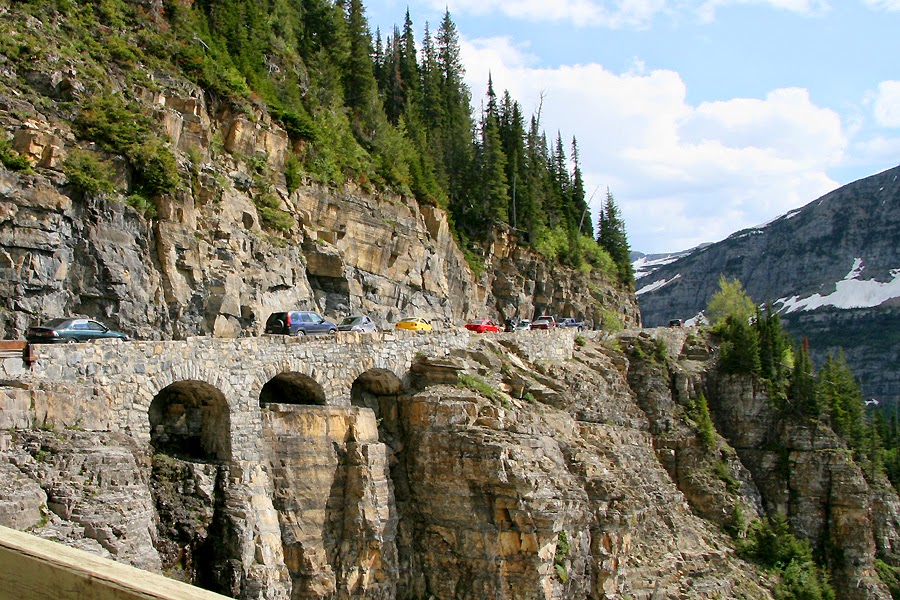 |
| The road was made in 1932, called the most beautiful structures in the Triple Arches - What do you think of going through the many cars may seem natural to look there are undermined, but you have to make a road rob make it so nice not seem too bad . Triple Arches in the past that we look around the corner to return to at the end of ... |
 |
| Logan Pass 2,670 m above the sea level rises in the snow-capped Rocky Mountains Clements is manifest themselves. |
 |
| It's been all work zones is wondering why I want another car, right next to the road because of the goat. Remaining snow remaining on the left side of the road to the axis of the neck, even as we get your car right in front of jaywalking and one reported being liked ^ ^ goats, went a little further we got off the car standing there are a lot of people turned out to walk along ... |
 |
| Goats were shown all the family. Shedding big guys going over it, I look back in the little goats are really cute. |
 |
| From here on, but came back after two hours. The boundaries of the Continental Divide and continue west down over now. |
 |
| Initially, the high mountains to the east and the west, beyond the sun rise and because of that connection, the name of the road 'Going-to-the-Sun' as-built thought, looking back on the show I saw in front of 2,939 m above sea level, Going-to- the-Sun Mountain was named after. White explorers in the late 1800s, Indians in the region "over the hill tail feathers (Tail-Feathers-Coming-Over-the-Hill) 'with it while hunting in the mountains to see rising towards the' run toward the sun (Going-to-the-Sun) mountain 'and built a name called. |
 |
| Continue south to the west of the Rocky Mountains, leading to Jackson Glacier flowing look away look. |
 |
| Now, almost all came down to the rugged region. However, the front view is shown in red rock mountains Why? |
 |
| He pulls on the Sun Point, west of St. See the views of Mary Lake. afternoon clouds, but the truth of the lake backlit was not feeling well. "Maybe I'll come back tomorrow morning ..." |
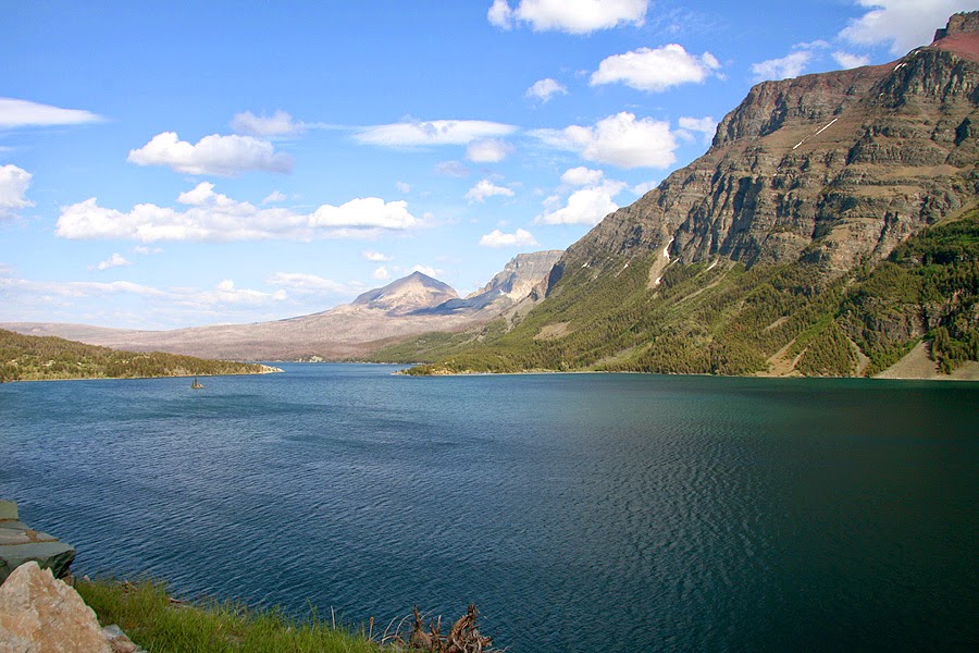 |
| Well to the east of the sky and the mountains, the lake's color-obvious story, but also photos of the 'light in the fight' is. |
 |
| Hurry St. Return to the visitor center at the park entrance to Mary's why wisdom Junior Ranger (Junior Ranger) was due. A young woman with a ranger, and then to review the brochure carefully, holding up his right hand to be a Junior Ranger oath. |
 |
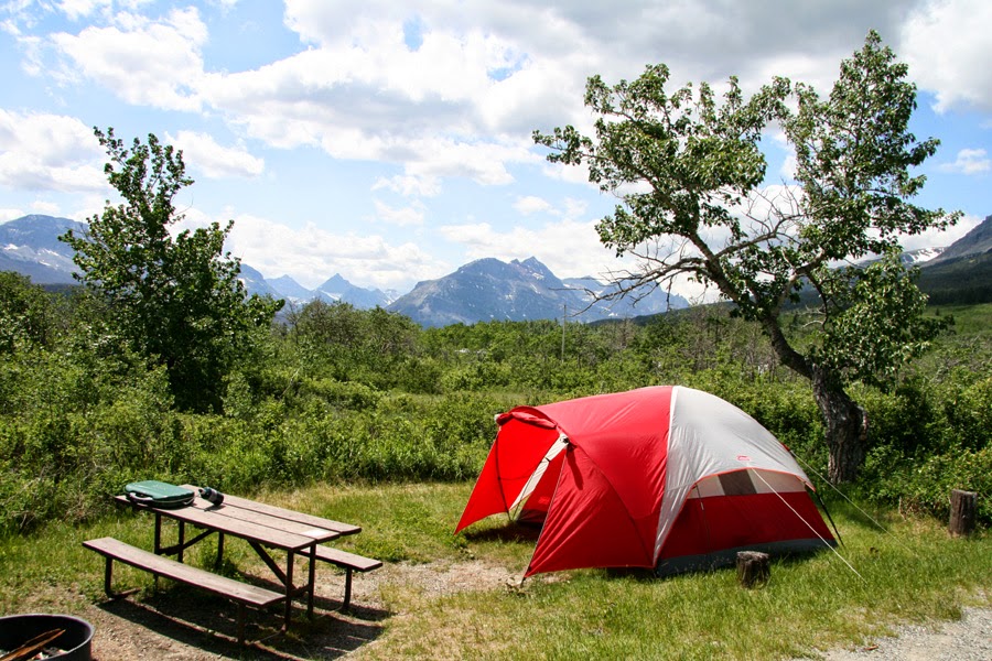
| Whether the high latitude dessert dinner eating marshmallows melted on the wood fire that did not dim at all. This 11 day trip to spend the night in a tent, the next morning St. Stopped by Lake Mary went over to Canada. |